BREAKING NEWS: Tropical Depression #OpongPH Accelerates Toward the Philippines – Nation on High Alert for Possible Severe Storm
An Alarming Development
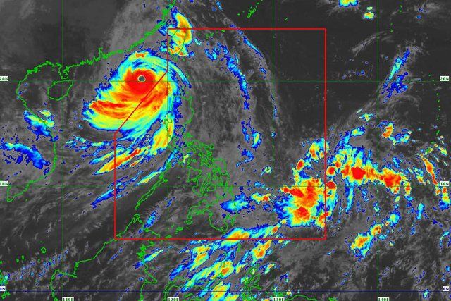
On the morning of Tuesday, September 23, meteorologists at the Philippine Atmospheric, Geophysical and Astronomical Services Administration (PAGASA) issued a startling advisory: a tropical depression had formed over the Philippine Sea, east of the country, and is accelerating toward the nation. The weather system, now officially designated as #OpongPH, has already triggered heightened warnings across Eastern Visayas and Bicol, with its rapid intensification threatening to bring heavy rainfall, damaging winds, floods, and landslides to millions of Filipinos.
At 10:00 a.m., the tropical depression was located 1,075 kilometers east of Eastern Visayas, packing maximum sustained winds of 55 km/h and gustiness reaching up to 70 km/h. Moving westward at a remarkable speed of 35 km/h, Opong is expected to enter the Philippine Area of Responsibility (PAR) by late Tuesday afternoon or evening.
The Threat of Intensification
Although currently classified only as a tropical depression, meteorologists are warning that Opong has the potential to strengthen into a tropical storm within the next 24 to 36 hours. The warm waters of the Philippine Sea and favorable atmospheric conditions may even allow it to reach the category of a severe tropical storm, or possibly escalate into a typhoon as it tracks northwestward.
PAGASA emphasized that while no immediate landfall is expected within the next 36 hours, residents should not be complacent. Beginning Wednesday morning, wind signals may be raised over Eastern Visayas, signaling the onset of stronger gusts and heavy rainfall.
By Thursday, significant rains are projected to affect large parts of the Visayas and Bicol regions, with the system predicted to reach peak intensity between Thursday and Friday.
Projected Path: A Direct Threat
Based on the latest forecast track, Tropical Depression Opong is expected to approach the Bicol-Eastern Visayas area by Friday, then potentially cross Southern Luzon between Friday evening and Saturday. If the system maintains its strength, the storm could exit PAR by late Saturday evening, though not before unleashing destructive weather over key regions.
This path puts millions of residents directly in harm’s way, with risks including:
Heavy to torrential rainfall that could lead to flash floods.
Mudslides and landslides, particularly in mountainous or deforested areas.
Strong winds capable of toppling power lines, damaging infrastructure, and destroying crops.
Coastal storm surges threatening low-lying coastal communities.
The danger is magnified by Opong’s forward speed, which allows less time for preparation while increasing the energy it carries into vulnerable provinces.
A Nation on High Alert
The Philippine government has begun coordinating its disaster preparedness protocols. The National Disaster Risk Reduction and Management Council (NDRRMC) has placed its regional units in Bicol, Eastern Visayas, and Southern Luzon on red alert. Local governments are already being urged to activate evacuation centers, stockpile relief goods, and prepare medical teams.
PAGASA issued a stern reminder:
“Residents of Eastern Visayas and Bicol must remain vigilant. The risk of flooding and landslides is high beginning Thursday, and further intensification of Opong into a severe tropical storm cannot be ruled out. Even if no immediate landfall occurs, the volume of rain associated with this system is enough to cause widespread disruption.”
Voices from the Ground

In Tacloban City, memories of Super Typhoon Yolanda (Haiyan) still haunt survivors. The announcement of another looming storm brought waves of anxiety.
“Every time we hear about a new typhoon forming, we panic,” said Marites Gonzales, a mother of three. “We have rebuilt our lives, but we are always afraid that one strong storm can destroy everything again.”
In the coastal town of Sorsogon, fishermen are already tying down boats and hauling equipment to safety. “We can’t take chances,” explained Mang Efren, a 58-year-old fisherman. “The sea is both our life and our enemy. When PAGASA says there’s a storm, we know we have to prepare.”
Historical Context: The Philippines and Storms
The Philippines sits squarely in the Pacific typhoon belt, making it one of the most disaster-prone countries in the world. On average, 20 tropical cyclones enter the PAR annually, with about 8 to 9 making landfall.
Some of the most devastating in history include:
Typhoon Haiyan (Yolanda) in 2013, which killed more than 6,000 people.
Typhoon Ulysses (Vamco) in 2020, which caused catastrophic flooding in Luzon.
Typhoon Odette (Rai) in 2021, which devastated large parts of Visayas and Mindanao.
Given this history, even the formation of a tropical depression like Opong instantly triggers nationwide concern.
PAGASA’s Warnings
As of the latest bulletin, PAGASA has not yet raised any Tropical Cyclone Wind Signals (TCWS), but stressed that Signal No. 1 could be raised in parts of Eastern Visayas by Wednesday morning. This would serve as an early warning for residents to brace for stronger winds and rain.
Key advisories include:
Avoid coastal waters. Fisherfolk and seafarers are strongly advised against venturing out into the eastern seaboards of Visayas and Mindanao.
Prepare emergency kits. Families are urged to secure food, clean water, batteries, flashlights, and medicine.
Monitor updates. Storm tracks can shift rapidly, and residents must stay tuned to hourly advisories.
Climate Change and Stronger Storms
Meteorologists have increasingly linked the intensity of storms to the broader impacts of climate change. Rising sea surface temperatures provide storms with more energy, allowing them to intensify faster and sustain stronger winds.
Dr. Enrico Lopez, a climate scientist at the University of the Philippines, warned:
“Opong may only be a tropical depression now, but in today’s climate reality, storms can explode into severe systems within hours. Rapid intensification is becoming the new normal.”
This raises critical questions about disaster readiness, infrastructure resilience, and the long-term strategies the Philippines must adopt to cope with increasingly hostile weather patterns.
The Human Side of the Crisis
Beyond meteorological charts and scientific discussions, storms like Opong always have a human toll. For millions of poor and vulnerable Filipinos, each approaching typhoon represents more than just a weather event—it is a direct threat to life, livelihood, and dignity.
Farmers fear losing crops that sustain their families. Fisherfolk dread days or weeks without the ability to fish. Urban slum dwellers, often living in makeshift housing near rivers or estuaries, face the horrifying prospect of floods washing away their homes.
Relief groups like the Philippine Red Cross and UNICEF Philippines have already mobilized volunteers. “Preparedness is everything,” said PRC chairman Richard Gordon. “We cannot stop the storm, but we can reduce its damage if people act early.”
Social Media Storm
As news of Opong spread, social media erupted. The hashtag #OpongPH quickly trended on Twitter and Facebook, with netizens sharing satellite images, memes, and prayer requests. Some expressed fear, while others criticized the government’s preparedness.
A viral tweet read:
“We cannot afford another disaster. Please, everyone, stock up and stay safe. Remember Yolanda.”
The digital response highlighted how storms in the Philippines are no longer just meteorological events but also social phenomena that spark nationwide conversations.
Looking Ahead: The Next 72 Hours
Meteorologists emphasize that the next three days will be critical in determining the true nature of Opong. If it continues to gather strength, the system could unleash severe impacts across multiple regions.
Projected timeline:
Tuesday evening: Opong enters PAR; initial advisories raised.
Wednesday morning: Possible issuance of TCWS over Eastern Visayas.
Thursday: Heavy rainfall begins across Bicol and Eastern Visayas.
Friday–Saturday: Potential landfall or passage through Southern Luzon; widespread flooding and landslides possible.
Saturday evening: System expected to exit PAR, leaving behind destruction and possible humanitarian emergencies.
Final Thoughts: Vigilance Is Survival
As of this writing, Tropical Depression #OpongPH is not yet the monster storm many fear. But the combination of its forward speed, potential for intensification, and projected path through vulnerable regions makes it a system that cannot be underestimated.
Filipinos are urged to stay calm but vigilant, prepare early, and heed all official advisories. History has shown too many times that underestimating a storm can be deadly.
“Preparedness saves lives,” PAGASA reminded in its latest statement. “Do not wait for the storm to arrive before you act.”
The entire nation now watches the skies, prays for mercy, and braces for what could be another devastating chapter in the Philippines’ long struggle with nature’s fury.
News

THE WORLD IS SHOCKED! The Truth About GuyCoy Is Finally Revealed – Only Believe What You See and Hear!”SHURRY WITH THE DEADLY QUESTION ABOUT GUYCOY – The Truth That Will Shock Everyone!” 👇Full story at the link! 👇
“The World Is Stunned: The Shocking Truth About GuyCoy – Only Believe What You Truly Hear and See” In the glittering, chaotic world of fandoms, few phenomena capture the collective attention of the globe like GuyCoy. Known for his charisma,…

NEWLY UPDATED NEWS “The identity of the murderer has been found: Yu Menglong” THE TRUTH HAS BEEN REVEALED IN THE ARTICLE … 👇Full story at the link! 👇
“The Shocking Revelation: Yu Menglong Identified as the Murderer” The world of entertainment thrives on illusions: bright lights, smiling faces, carefully curated images of perfection. Yet sometimes, reality intrudes in the most brutal ways, shattering the veneer and leaving the…

GLOBAL STUNNING!“ Horrifying Video: Shiqi Fan Sends Photos of Yu Menglong Convulsing Before His Mysterious Death ” THE TRUTH REVEALED IN THE ARTICLE … 👇Full story at the link! 👇
“Shocking Footage Emerges: Yu Menglong’s Final Moments Captured by Fan Shiqi” The world of entertainment rarely stops for anyone. Fame, fortune, and public adoration move at a speed that seems relentless. Yet, every so often, an event occurs that freezes…

THE WHOLE SET IS SHOCKED! Joey de Leon shocked everyone when he publicly insulted Alexandra Eala and her family, sending shockwaves through the Eat Bulaga! set. While some viewers were outraged by the sexual provocation, fans suspected he was trying to cover up the $25.5 million scandal. But it was Eala’s 12-word response that left Joey bowing his head in silence…? 👇Full story at the link! 👇
“The Showdown at Eat Bulaga: Alexandra Eala’s 12-Word Comeback” The lights of the Eat Bulaga! stage had never seemed so bright, yet the air that day was thick with tension. In a studio usually filled with laughter, applause, and spontaneous…

SHOCKING ENTERTAINMENT INTRODUCTION! Fans went wild when Ryan Bang suddenly announced the closure of Siesta Horchata, the coffee shop he and Paola Huyong built together. Rumors spread that this was not just “the end of a brand” but “the end of a story”. The words “Thank you for making us possible” on the corrugated iron sheet made netizens believe that their love had melted away like the last layer of coffee foam – sweet, then disappeared. “Farewell in silence” – When the last cup of coffee is a love story!!! 👇Full story at the link! 👇
💔 “When the Last Cup Grows Cold” In the glossy world of Maharlia’s entertainment industry, where headlines usually revolved around box-office records and celebrity engagements, this one felt strangely personal: “Luna Breve Café to close this November.” No scandal. No…

MAHARLIA IS COUNTDOWN! A close minister abruptly resigns, leaving behind a 48-page letter denouncing a hidden power structure that “is dominating President Verano.” The letter, along with a list of seven secret financial figures, has led to the resurgence of the Soliano bloc, which is calling for the “rescue of the republic.” As the population divides, intelligence satellites detect a series of encrypted signals from the Presidential Palace. Is this the beginning of a global political coup? 👇Full story at the link! 👇
“The Maharlia Countdown” The capital city of Aurelia had never felt so tense. Beneath the golden domes of the Republic Palace, a storm was gathering—quiet, invisible, but powerful enough to rewrite history. It began with a single message: “I resign.”…
End of content
No more pages to load